MARKER ADVOCATES of TOBYHANNA TOWNSHIP
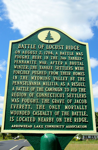
BATTLE OF LOCUST RIDGE

View of Locust Ridge near Pocono Pines, site of a battle during the Third Yankee-Pennamite War in 1784.
(The inscription on this postcard, circa 1910, has an incorrect date.)
COMMEMORATES: The Battle of Locust Ridge was one of the final skirmishes in the 15-year dispute between Connecticut (Yankee) and Pennsylvania (Pennamite) settlers over overlapping land claims in the Wyoming Valley along the North Branch of the Susquehanna River.
INSCRIPTION: On August 2, 1784, a battle was fought here in the 3rd Yankee-Pennamite War. After a brutal winter, the Yankee settlers were forcibly pushed from their homes in the Wyoming Valley by the Pennsylvania militia. As a result, a battle of the campaign to rid the region of Connecticut settlers was fought. The grave of Jacob Everett, the only mortally wounded casualty of the battle, is located nearby on the ridge.
MARKER DEDICATED: September 3, 2016
SPONSOR: 2016 | Arrowhead Lake Community Association
LOCATION: On Locust Ridge Road in Pocono Pines, just south of Slutter Road
COORDINATES: 41° 07' 50.1"N 75° 33' 16.3"W
or 41.130598, –75.554527
GPS ADDRESS: 45 Locust Ridge Road, Pocono Lake, PA 18347
READ MORE:
TOBYHANNA TOWNSHIP MARKERS:
- Agriculture
- Battle of Locust Ridge
- Blakeslee United Methodist Church
- Blakeslee Community Center
- Easton & Wilkes-Barre Turnpike
- Eschenbach Cemetery
- First Fire Company & Clymer Library
- First Schoolhouse
- Forest Products Industry
- General Sullivan Bridge
- The Great Swamp
- Harrison Amusement Park
- Hungry Hill
- Ice Harvesting Industry
- Isaac Stauffer – King of the Poconos
About the Tobyhanna Township Roadside Marker Program
The Tobyhanna Township Roadside Historical Marker Program is a community-wide, volunteer effort spearheaded by the Marker Advocates of Tobyhanna Township (MATT).
MATT is a nonprofit association dedicated to this program. Volunteers serving in committees seek the funding, research and write the text, install the markers, arrange for a public dedication and establish a long-term awareness campaign through a touring map and a web site.
Be part of our heritage — Donate an historical marker- Through identification of the important facets of our rich history ... existing and lost landmarks, important events and activities, and our people, we will realize the goal of a community-wide network of roadside historical markers. Our community can now and for future decades and generations appreciate our heritage.
- Each roadside historical marker will ensure the preservation of our local history and heritage, while providing an important educational opportunity that is accessible to the public, free of charge.
- This program will build community pride while enhancing “heritage tourism,” recognized as a strong and desirable sector of our economy.
Sponsors donating the full cost of a marker are permanently recognized on the bottom of the marker. Additional appreciation is shared with the community through a public dedication ceremony, as well as a touring map, web site and other materials.
For more information on becoming a sponsor:
Email us
For more information on becoming a sponsor:
Email us