MARKER ADVOCATES of TOBYHANNA TOWNSHIP
AGRICULTURE

COMMEMORATES:
Farming was the mainstay of the township existence and growth in our formative years, despite the rough Pocono terrain.
INSCRIPTION:
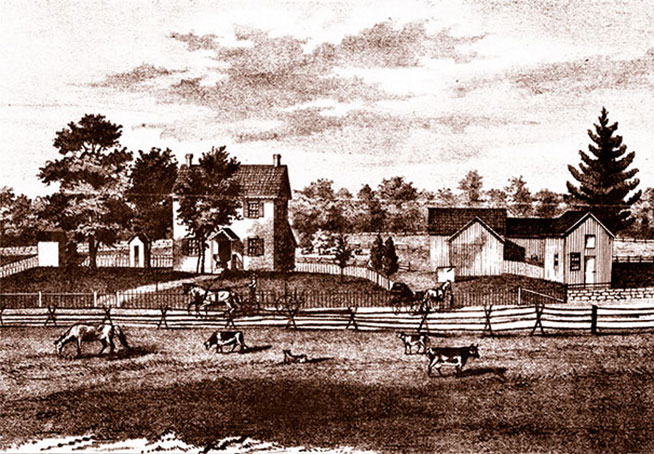
As lumbering cleared our thick forests, farming grew into a local industry. By 1880, over 60 farms covered almost 7,000 acres in the township. Major crops were buckwheat, oats, rye, potatoes, wheat, corn and hay. Farm produce, dairy, poultry and eggs were sold to local users and the resort industry. Yields were also shipped by rail to the coal fields and metro New York. A 400 acre farm was operated here by the Austin T. Blakeslee family, from the mid-1800s to the 1960s.
SPONSOR:
Marker Advocates of Tobyhanna Township
MARKER DEDICATED: September 25, 2021
LOCATION:
Sir Bradford Road, Camelot Forest near Blakeslee off Route 940, by the tennis courts. (Past 302-312 on left).
COORDINATES: 41°05'45.8"N 75°34'40.8"W
or 41.096054, -75.577994
GPS ADDRESS: Sir Bradford Road, Blakeslee, PA 18610
READ MORE:
Farming was the mainstay of the township existence and growth in our formative years, despite the rough Pocono terrain.
INSCRIPTION:
As lumbering cleared our thick forests, farming grew into a local industry. By 1880, over 60 farms covered almost 7,000 acres in the township. Major crops were buckwheat, oats, rye, potatoes, wheat, corn and hay. Farm produce, dairy, poultry and eggs were sold to local users and the resort industry. Yields were also shipped by rail to the coal fields and metro New York. A 400 acre farm was operated here by the Austin T. Blakeslee family, from the mid-1800s to the 1960s.
SPONSOR:
Marker Advocates of Tobyhanna Township
MARKER DEDICATED: September 25, 2021
LOCATION:
Sir Bradford Road, Camelot Forest near Blakeslee off Route 940, by the tennis courts. (Past 302-312 on left).
COORDINATES: 41°05'45.8"N 75°34'40.8"W
or 41.096054, -75.577994
GPS ADDRESS: Sir Bradford Road, Blakeslee, PA 18610
READ MORE:
Tobyhanna Township Farming
By Rick Bodenschatz
Prepared September 2015
Source: Historic Agricultural Resources of Pennsylvania, c. 1700-1960
Stillwater Lake is located in Pocono Summit, and the communities of Stillwater Lake and Stillwater Estates partially surround its shore. A large portion of the shoreline, as well as the lake itself, is the responsibility of Camp Minsi, Boy Scouts of America.
The lake area is located in both Tobyhanna Township and Coolbaugh Township, covering a surface of approximately 315 acres. It is 0.87 mile in length and 1.25 mile wide. The lake reaches depths of approximately 8 feet, with the average being 4.7 feet. It is located 1,811 feet above sea level.
Stillwater Lake is a man-made lake, being fed by several underground springs and the three streams of Dotter’s Run (the primary feed), Hawkeye Run and Pocono Summit Creek. The outflow of the lake forms the Upper Tunkhannock Creek, which flows to, through and beyond Lake Naomi.
Up to the 1850s:
Six (6) farms of record were reported in the 1850 Census. No buckwheat was farmed and 65 bushels of potatoes were reported to be harvested.
Conclusion: With less than 400 residents including children, farming was predominately subsistence by landowners and tenants. Although there was garden/truck farming occurring for summer vegetables for a few local merchants, most was used to supplement the payment of wages and subsistence. With no regional markets creating significant demand and only horse-drawn wagon transportation, the larger town markets such as Stroudsburg were served by small farms located closer to those markets. The township was still largely covered by forests and swamps, with lumbering slowly opening the land for farming.
1860-World War I:
A number of factors established agricultural activity as an important part of the economy for Tobyhanna Township. Along with lumbering, these were the two most significant economic drivers until the ice-harvest industry began in 1896. Although agriculture is more associated with man-planted crops and not the harvest of nature, there is no question that there was synergy of these three activities, all harvesting the bounty of nature.
Soil conditions in Tobyhanna Township were and are exceptionally rocky, as a result of the area being the terminal moraine of the last glacier (Wisconsin) approximately 11,000 years ago. But with the forest growth eventually being a significant, stable factor for several thousand years, the forest decay matter created a remarkably rich soil.
As the timber industry reaped its gain from the cutting of timber, it had little interest in the resulting cleared land. Prices for acres of land were cheap. For any enterprising person willing to accept the backbreaking task of clearing the land of stumps and rocks, acreage for a farm was relatively inexpensive.
The four most significant drivers enabling farming in the period 1860 to World War I were:
- The building of the Railroads: DL&W RR (1856) and the WB&E RR (1895), improving transportation to metropolitan markets for farm products.
- As The Civil War demanded more food for the war effort, it also created more employment in towns and cities. Our east coast grew significantly, increasing demand, along with more money in pockets.
- Post-war growth created demand as our country grew. Regionally, the Coal Mining Industry boomed, with towns springing up all around the region virtually overnight. Demand grew for inexpensive food products such as potatoes, buckwheat, rye, and other products such as corn, wheat, dairy products and meat.
- With a post-war economy and overall metropolitan growth, the Resort Industry started to become a significant factor in in our immediate area in the 1880’s. Delaware Water Gap, the Stroudsburg’s, Mount Pocono and then closer to home- Resorts such as Naomi Pines House, then the Laurel Inn, the Lake View House among others. Then the turn of the century brought The Pocono Pines Assembly, Pocono Manor, Buck Hill, Skytop and others. (Lewis Store was a long-time supplier to Skytop.) Summer homes, camps and camping were becoming a factor, along with hunting and fishing enthusiasts, such as Pocono Lake Preserve. These were served by local merchants in the township such as Bonser’s General Store, Pocono Lake Fruit Market (Lewis Store), Henning’s Store and Blakeslee Market.
- Tobyhanna Township was predominantly forest (western section) and swamps (eastern section) as it was settled in the 1800s. Little open land was available for farming until the Lumbering Industry cleared the land. By 1880, significant lumbering operations cleared so much that farming had grown to be significant.
By 1880, the population of Tobyhanna Township grew to a resounding 800+ residents. The following provides a picture of farming in the 1880s as it continued to grow:
- Farming in 1880 in Tobyhanna Township:
- Number of farms: 64
- Tilled Acres: 2,300
- Orchards and pasture acres: 1,145
- Total acres of farms: 6,976 (includes tilled, pastures, building, barnyard, woods)
- Value of farm products sold: $42,650. (Ninth overall in Monroe County of 14 townships with farms.)
- Principle products: Buckwheat (8,350 bushels) and potatoes (7,700 bushels) — Eighth in Monroe County in each.
Tobyhanna Township showed a production level of the 75th percentile of the entire region’s production. This is remarkable considering the mix of valley, less harsh conditions of both weather and soil (rock) conditions.
Rye, wheat, oats and corn were also produced in enough quantities to be measured by the stat’s survey.
The resource reports that although the other parts of Pennsylvania grew the complete range of agricultural products, in the Pocono resort and anthracite coal region from 1860 to 1960, “counties show proportionately a great emphasis upon potatoes, buckwheat and rye. Potatoes were an inexpensive staple and key to the diet in mining communities, and in greater demand there. In Carbon and Monroe Counties particularly, these were areas with soils well adapted to potato culture.”
Buckwheat can also “be fed to livestock, and can withstand cold weather and thin soils.” (Note: Tobyhanna Township is located centrally to both counties.)
Within the resources report, only Tobyhanna and Ross townships were selected from Monroe County to show a bar graph representation of a distinctive profile of agriculture in the reason.
Local examples:
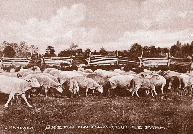
In Matthew’s 1886 History of Wayne, Pike and Monroe Counties, Pennsylvania he cites an example of farming in the area by Jacob Blakeslee, who provides quoted information and cites:
“In 75 acres under cultivation, I have not raised wheat since 1879; then I had over 25 bushels per acres. The production of rye in last year’s crop was very good but I did not measure the amount. The production of oats was 55 bushels per acre, corn on ear 50 bushels per acre, potatoes 125 bushels per acre, hay 2 tons per acre. Apples ….are very plentiful. Also Pears, Plums and the small fruits are produced in abundance.”
“In speaking of the history of this place, I may say that thirty-five years ago this region was a dense forest. At that time lumbering was the chief industry. Since then the country has been cleared by cutting and fire, so that now there is comparatively level, open country, interspersed with clumps of woodland. With the removal of the forest the people turned to agriculture, and with great success. As the proof of the richness of the soil, I add that land first cleared raises very fine and heavy crops of hay for six years without fertilization. As a pasturage land this region is unequaled.”
Miscellaneous:
Although wild blueberry harvesting certainly cannot be considered cultivated agriculture, some consideration must be given due to the farm cultivation. Frederick’s book on the WB&E railroad, Page 31, states that “The berries grew abundantly in the highlands, both cultivated and uncultivated.”
And he further refers to the “special Huckleberry trains” on Page 47. He further states, “Dealers hired berry pickers by day, week and season, providing them with food and lodging.” Boxcars were placed on side rails at the Naomi Pines station and Wagner’s Switch station, and would be filled by berry pickers in a few days, for transport to city markets.
Fredericks describes dairy products interaction with the WB&E by stating on Page 32, “Creameries were established at Bartonsville and Stauffers” (Pocono Lake station area of Stoney Hollow Road). “Daily milk train ran from Little Summit (corner of Sullivan Trail and Long Pond Road in Tobyhanna Township) to Jersey City.”
The DL&W Railroad also had special milk trains with pickup in Pocono Summit. We also know there was a dairy in Pocono Pines near the Pocono Lake cemetery.
Also on Page 32, Fredericks speaks of farm products being shipped from the area, stating, “Farm products were shipped from all stations between Bartonsville and Clifton (north on the WB&E towards Wilkes-Barre). This included vegetables, fruits, eggs, milk, chickens and livestock.”
Many descendants of 19th and early 20th century farmers are with us today.
The Yankee Pennymite War of the 1770s and 1780s was all about the farmers from Connecticut taking land in Pennsylvania to establish farms since they found the CT soil too rocky to farm to their satisfaction. Their incursion into Tobyhanna Township in an attempt to settle. It resulted in the Battle of Locust Ridge.
Although it was a financial bust, the canals & locks on the Lehigh River at Stoddartsville were intended to aid in transport of grain to Philadelphia.
Post World War I:
As the country industrialized and the breadbasket of America in the mid-west developed, small farms in the east bowed to the progress of time. According to the state report, in 1927, only 11 farms remained in Tobyhanna Township, farming 77 acres of buckwheat and 30 acres of potatoes.
Farming on a commercial basis existed for many years of our history. It was a very significant part of our economy, being seconded only by lumbering, and then ice harvesting, during the years 1860 to 1920. Considering the average number of family members in those years, and hired hands showing on census reports, it comprised a fairly significant percentage of our resident population.
TOBYHANNA TOWNSHIP MARKERS:
- Agriculture
- Battle of Locust Ridge
- Blakeslee United Methodist Church
- Blakeslee Community Center
- Easton & Wilkes-Barre Turnpike
- Eschenbach Cemetery
- First Fire Company & Clymer Library
- First Schoolhouse
- Forest Products Industry
- General Sullivan Bridge
- The Great Swamp
- Harrison Amusement Park
- Hungry Hill
- Ice Harvesting Industry
- Isaac Stauffer – King of the Poconos
About the Tobyhanna Township Roadside Marker Program
The Tobyhanna Township Roadside Historical Marker Program is a community-wide, volunteer effort spearheaded by the Marker Advocates of Tobyhanna Township (MATT).
MATT is a nonprofit association dedicated to this program. Volunteers serving in committees seek the funding, research and write the text, install the markers, arrange for a public dedication and establish a long-term awareness campaign through a touring map and a web site.
Be part of our heritage — Donate an historical marker- Through identification of the important facets of our rich history ... existing and lost landmarks, important events and activities, and our people, we will realize the goal of a community-wide network of roadside historical markers. Our community can now and for future decades and generations appreciate our heritage.
- Each roadside historical marker will ensure the preservation of our local history and heritage, while providing an important educational opportunity that is accessible to the public, free of charge.
- This program will build community pride while enhancing “heritage tourism,” recognized as a strong and desirable sector of our economy.
Sponsors donating the full cost of a marker are permanently recognized on the bottom of the marker. Additional appreciation is shared with the community through a public dedication ceremony, as well as a touring map, web site and other materials.
For more information on becoming a sponsor:
Email us
For more information on becoming a sponsor:
Email us